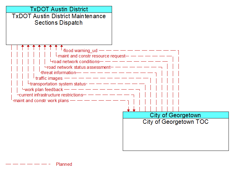
Interface: TxDOT Austin District Maintenance Sections Dispatch - City of Georgetown TOC
Architecture Flow Definitions
current infrastructure restrictions (Planned) Applicable ITS Standards
Restrictions levied on transportation asset usage based on infrastructure design, surveys, tests, or analyses. This includes standard facility design height, width, and weight restrictions, special restrictions such as spring weight restrictions, and temporary facility restrictions that are imposed during maintenance and construction.
flood warning_ud (Planned)
Flood warning information sent from one center to another.
maint and constr resource request (Planned) Applicable ITS Standards
Request for road maintenance and construction resources that can be used in the diversion of traffic (cones, portable signs), clearance of a road hazard, repair of ancillary damage, or any other incident response. The request may poll for resource availability or request pre-staging, staging, or immediate dispatch of resources.
maint and constr work plans (Planned) Applicable ITS Standards
Future construction and maintenance work schedules and activities including anticipated closures with anticipated impact to the roadway, alternate routes, anticipated delays, closure times, and durations.
road network conditions (Planned) Applicable ITS Standards
Current and forecasted traffic information, road and weather conditions, and other road network status. Either raw data, processed data, or some combination of both may be provided by this flow. Information on diversions and alternate routes, closures, and special traffic restrictions (lane/shoulder use, weight restrictions, width restrictions, HOV requirements) in effect is included.
road network status assessment (Planned) Applicable ITS Standards
Assessment of damage sustained by the road network including location and extent of the damage, estimate of remaining capacity, required closures, alternate routes, necessary restrictions, and time frame for repair and recovery.
threat information (Planned) Applicable ITS Standards
Threats regarding transportation infrastructure, facilities, or systems detected by a variety of methods (sensors, surveillance, threat analysis of advisories from outside agencies, etc.
traffic images (Planned) Applicable ITS Standards
High fidelity, real-time traffic images suitable for surveillance monitoring by the operator or for use in machine vision applications. This flow includes the images and meta data that describes the images.
transportation system status (Planned) Applicable ITS Standards
Current status and condition of transportation infrastructure (e.g., tunnels, bridges, interchanges, TMC offices, maintenance facilities). In case of disaster or major incident, this flow provides an assessment of damage sustained by the surface transportation system including location and extent of the damage, estimate of remaining capacity and necessary restrictions, and time frame for repair and recovery.
work plan feedback (Planned) Applicable ITS Standards
Comments and suggested changes to proposed construction and maintenance work schedules and activities. This information influences work plan schedules so that they minimize impact to other system operations and the overall transportation system.