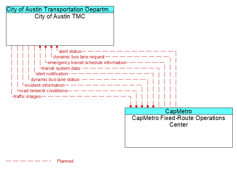
Interface: City of Austin TMC - CapMetro Fixed-Route Operations Center
Architecture Flow Definitions
alert notification (Planned) Applicable ITS Standards
Notification of a major emergency such as a natural or man-made disaster, civil emergency, or child abduction for distribution to the public. The flow identifies the alert originator, the nature of the emergency, the geographic area affected by the emergency, the effective time period, and information and instructions necessary for the public to respond to the alert. This flow may also identify specific information that should not be released to the public.
alert status (Planned) Applicable ITS Standards
Information indicating the current status of the emergency alert including identification of the traveler and driver information systems that are being used to provide the alert.
dynamic bus lane request (Planned) Applicable ITS Standards
Request for a restricted bus lane.
dynamic bus lane status (Planned) Applicable ITS Standards
Status of dynamic lane request, identifying if the request can be met, and the specific lane, start, end location, and time period where priority or exclusive access is to be granted.
emergency transit schedule information (Planned) Applicable ITS Standards
Information on transit schedule and service changes that adapt the service to better meet needs of responders and the general public in an emergency situation, including special service schedules supporting evacuation.
incident information (Planned) Applicable ITS Standards
Notification of existence of incident and expected severity, location, time and nature of incident. As additional information is gathered and the incident evolves, updated incident information is provided. Incidents include any event that impacts transportation system operation ranging from routine incidents (e.g., disabled vehicle at the side of the road) through large-scale natural or human-caused disasters that involve loss of life, injuries, extensive property damage, and multi-jurisdictional response. This also includes special events, closures, and other planned events that may impact the transportation system.
road network conditions (Planned) Applicable ITS Standards
Current and forecasted traffic information, road and weather conditions, and other road network status. Either raw data, processed data, or some combination of both may be provided by this flow. Information on diversions and alternate routes, closures, and special traffic restrictions (lane/shoulder use, weight restrictions, width restrictions, HOV requirements) in effect is included.
traffic images (Planned) Applicable ITS Standards
High fidelity, real-time traffic images suitable for surveillance monitoring by the operator or for use in machine vision applications. This flow includes the images and meta data that describes the images.
transit system data (Planned) Applicable ITS Standards
Current transit system operations information indicating current transit routes, the level of service on each route, and the progress of individual vehicles along their routes for use in forecasting demand and estimating current transportation network performance.