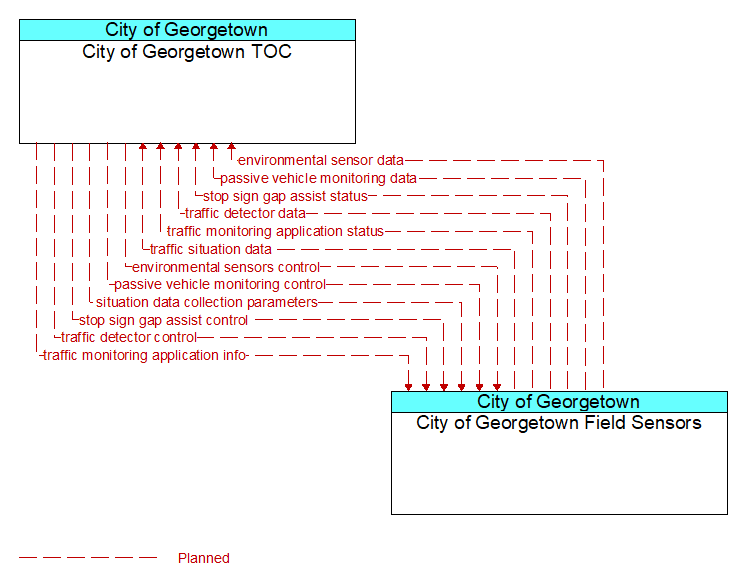
Interface: City of Georgetown TOC - City of Georgetown Field Sensors
Architecture Flow Definitions
environmental sensor data (Planned) Applicable ITS Standards
Current road conditions (e.g., surface temperature, subsurface temperature, moisture, icing, treatment status) and surface weather conditions (e.g., air temperature, wind speed, precipitation, visibility) as measured and reported by fixed and/or mobile environmental sensors. Operational status of the sensors is also included.
environmental sensors control (Planned) Applicable ITS Standards
Data used to configure and control environmental sensors.
passive vehicle monitoring control (Planned) Applicable ITS Standards
Control commands used to control detection systems that rely on infrastructure-based identification of individual vehicles to measure travel times and other related measures by identifying the same vehicle at different points in the network. Related technologies include bluetooth readers and license plate recognition systems.
passive vehicle monitoring data (Planned) Applicable ITS Standards
Time stamped identifiers that identify the vehicles that have passed through a detection zone.
situation data collection parameters (Planned) Applicable ITS Standards
The parameters that are used to control the flow of situation data from the RSE. This flow identifies the type of data/snapshots that are requested from passing vehicles and reporting parameters such as snapshot frequency, filtering criteria (data thresholds for reporting), and reporting interval that control the type and volume of data reported to the back office center.
stop sign gap assist control (Planned) Applicable ITS Standards
Configuration and control of detectors that monitor traffic on the major road and signs that provide stop sign gap assist alerts and warnings to vehicles on the minor road.
stop sign gap assist status (Planned) Applicable ITS Standards
The current operational state and status of the field controller, sensors, and signs that support the stop sign gap assist application.
traffic detector control (Planned) Applicable ITS Standards
Information used to configure and control traffic detector systems such as inductive loop detectors and machine vision sensors.
traffic detector data (Planned) Applicable ITS Standards
Raw and/or processed traffic detector data which allows derivation of traffic flow variables (e.g., speed, volume, and density measures) and associated information (e.g., congestion, potential incidents). This flow includes the traffic data and the operational status of the traffic sensor system.
traffic monitoring application info (Planned) Applicable ITS Standards
Traffic monitoring application parameters and thresholds that control the filtering, aggregation, and range of measures that are collected, derived, and reported. This flow also supports remote control of the application so the application can be taken offline, reset, or restarted.
traffic monitoring application status (Planned) Applicable ITS Standards
Traffic monitoring application status reported by the RSE. This includes current operational state and status of the RSE and a record of system operation.
traffic situation data (Planned) Applicable ITS Standards
Current, aggregate traffic data collected from connected vehicles that can be used to supplement or replace information collected by roadside traffic detectors. It includes raw and/or processed reported vehicle speeds, counts, and other derived measures. Raw and/or filtered vehicle control events may also be included to support incident detection.